This is intended as a very
brief explanation of the Carto-Bibliography. It will give the layman,
or the person stumbling on this web site for the first time, a fighting
chance of understanding the basics of the documentation's cryptic
notation.
The documented printed maps of Kent have been arranged in chronological
order of publication or printing. They are numbered from 1(earliest) to
216 (latest). Variations of a particular map, such as later
editions or modifications are sub-notated in small case Roman numerals
( ie 3i, 3ii, 3iii etc)
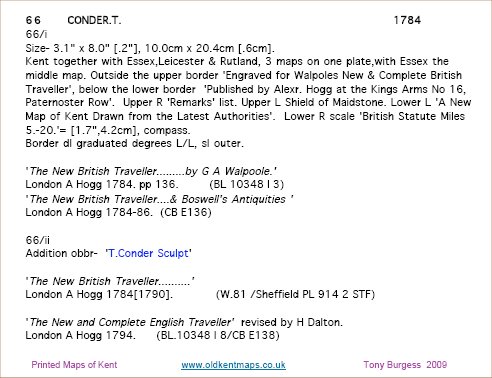
The illustration below shows a short, example entry from the reference
work.
This is the description for the map on the home page of this web site.
It is also listed on the 'Images' page.
The basic Reference number
is 66, the map maker is Thomas Conder and publication date is
1784.
This is the 66th map in the chronological list.
The entry shows 2 versions of the map, referenced as 66/i and 66/ii
The first entry will always show the full description.
Some of the description is obvious and some is cryptic. For a
full decoding of the notation please see the introduction chapter of
the reference work.
The first entry will also show the publications that contained the map.
Subsequent entries ( here it is 66/ii) will only carry information on
variations in later editions. In this case the text 'T. Conder Sculpt'
was added. Publications for this edition are also shown. Dates
that appear in square braces indicate a later issue, or publication, of
the same basic map or book.
From the documentation of item 66 it can be quickly deduced that this
map of Kent was first produced for two publications in 1784 and was
later released with a modification in 1790 and 1794.
A mention should be given to the definition of 'Cartographer' or 'Map
maker'.
This is a minefield of confusion and misunderstanding, following years
of misleading attributions.
The process of producing these maps involves an artist or creator, an
engraver, a publisher, and sometimes a writer of the particular
reference work. Historically, any of these has been given the popular
attribution of 'map maker'.
For the purposes of this work an order of precedence has been
structured:
1 Artist / drafter / originator / survey / compiler of
geographical data.
2 (if 1 is unknown) Original Engraver, sometimes
with Lithographer on later states.
3 (if 1 & 2 are unknown) Publisher or author of
the publication containing the map.
As a result, there may be some initial difficulty in locating some
popularly known maps. As an example the Van den Keere, or Miniature
Speed as it is sometimes called, is under the Cartographer of Humble (
map ref 11 ). This reflects the historical accuracy of Pieter Van
den Keere having nothing to do with the Kent map.
For further guidance see the introduction chapter of the main reference
work.
Web site designed by Tony
Nicholls www.pastpages.co.uk