| Postcard Image Page This page is a work in progress and will attract additions as time permits. Click image for an enlarged view. The images are all displayed in landscape format. |
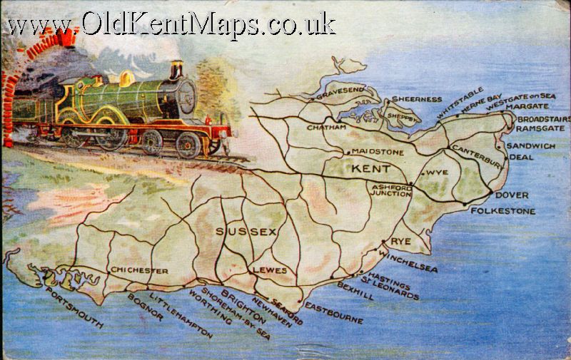 |
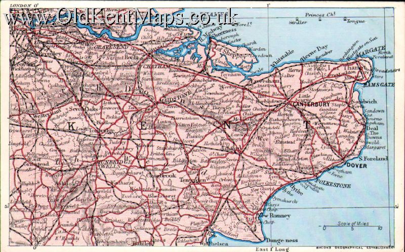
W.E.Mack Nº 1. South Coast showing Kent,Sussex,& pt of Hampshire with the Railway network. [1920] |
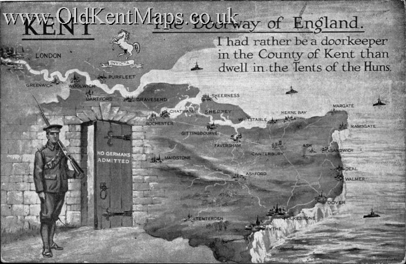 |
Voile & Robertson Nº 1. Stylised Map of Kent Coast with Soldier on Guard. Patriotic [1915] |
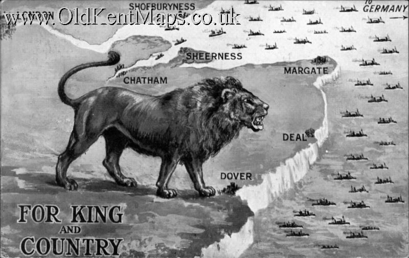 |
The Woodland Card Co.,Ltd., Nº 1. Stylised Map of Kent Coast with Lion on Guard. Patriotic [1915] |
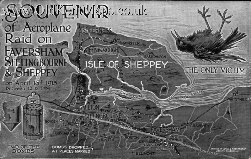 |
Voile & Robertson Nº 2. Stylised Map of Kent / Isle of Sheppey Coast with bomb sites and dead bird Patriotic [1915] |
 |
G.W.Bacon & Cº. Ltd., Nº 4. Map of Kent possibly taken from the Dispatch Atlas. [1907] |
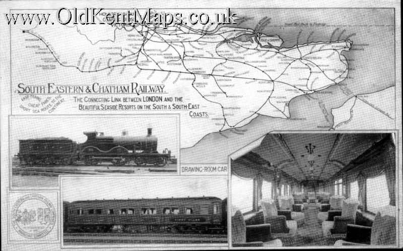 |
McCorquodale & Cº Limited. Nº 1. Map of the South Eastern & Chatham Railway System. Kent,Sussex,London on towards Reading. [post 1918] |
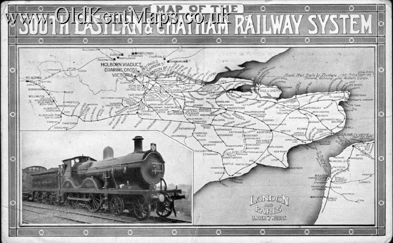 |
McCorquodale & Cº Limited. Nº 2. Map of the South Eastern & Chatham Railway System Kent,Sussex,London Reading with routes down to Southampton. [1913] |
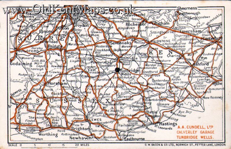 |
G.W.Bacon & Cº. Ltd., Nº 8. Map of London South to Kent,Surrey & Sussex. [between 1920-42] |
|
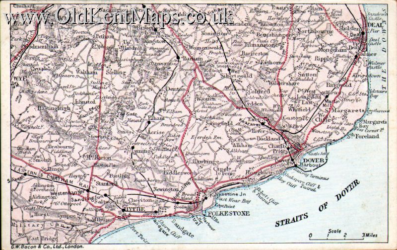
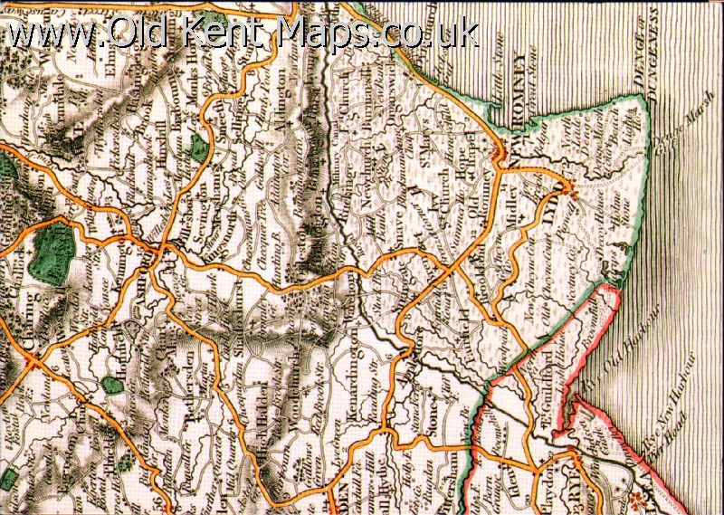
G.W.Bacon & Cº. Ltd., Nº 3. Map of the Coast South from Deal to Hythe. [1907-] |

|
G.W.Bacon & Cº. Ltd., Nº 5. Map of London Environs South to the Coast around Brighton & Eastbourne. [1907-] |
|
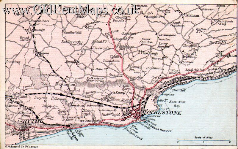
G.W.Bacon & Cº. Ltd., Nº 1. Map of Folkestone and Hythe Environs. [1907-] |
|
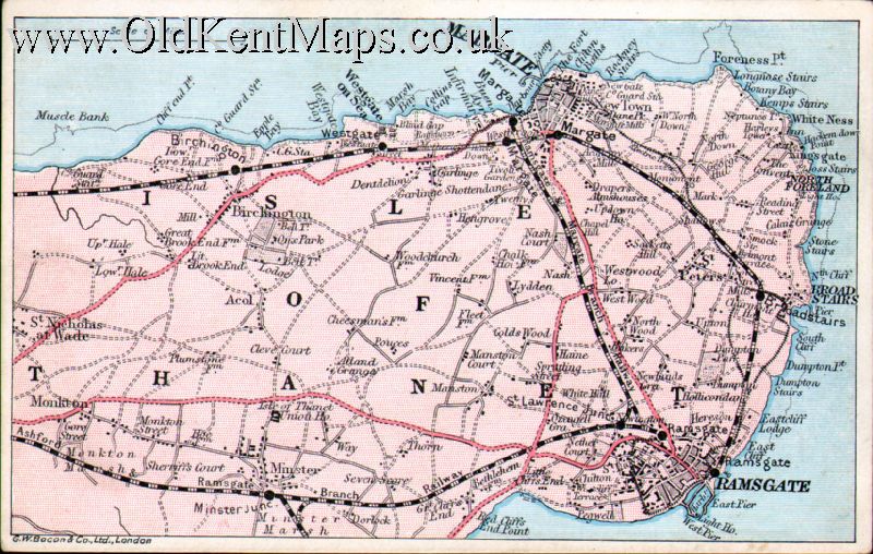
G.W.Bacon & Cº. Ltd., Nº 2. Map of The Isle of Thanet . [1907-] |
|
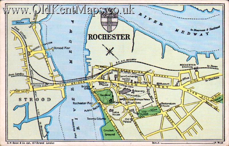
G.W.Bacon & Cº. Ltd., Nº 6. Plan of the City of Rochester. [1907-18] |

|
G.W.Bacon & Cº. Ltd., Nº 7. Map of the Environs of Tonbridge and Tunbridge Wells. [post 1923] |
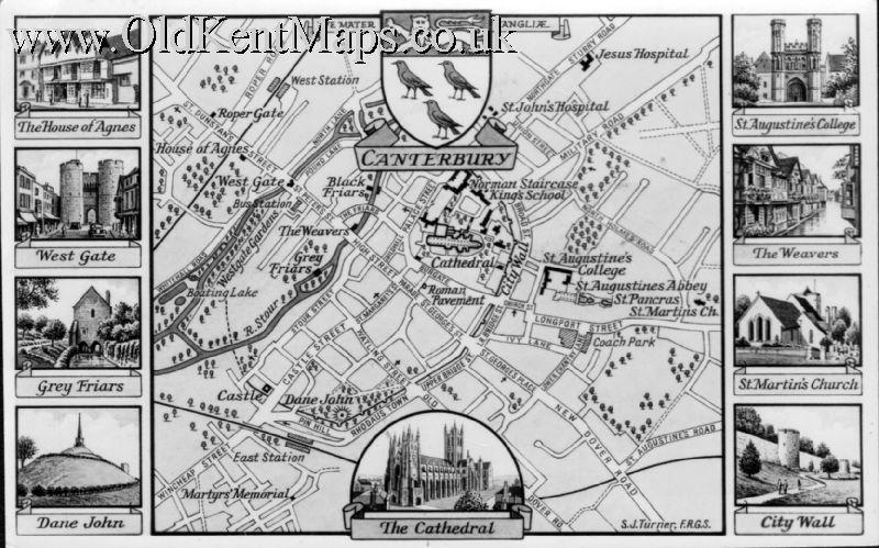 |
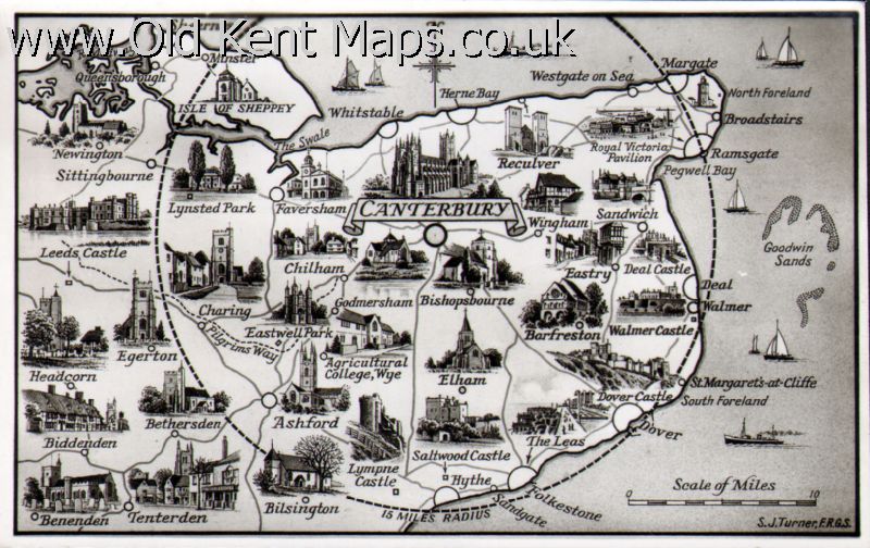
Shoesmith & Etheridge Ltd Nº 4. Plan of City of Canterbury by S.J.Turner F.R.G.S. [1930s?] |
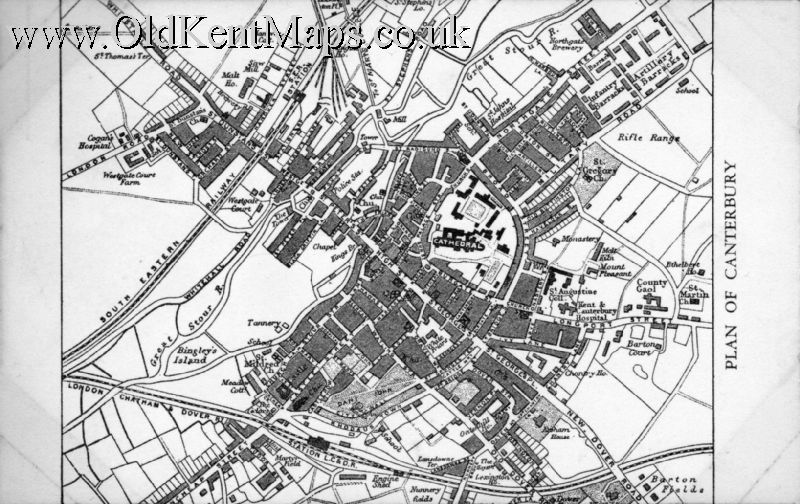 |
H.J. Goulden. Ltd,. Nº 1. Plan of Canterbury side borders only unsigned [pre 1923] |
|
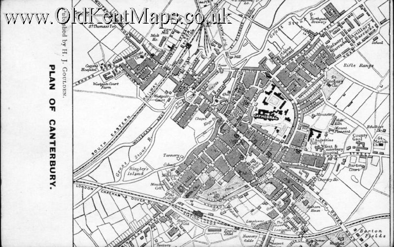
H.J. Goulden. Ltd,. Nº 2. Plan of Canterbury side borders only signed [pre 1923] |
|
F.Frith & Co.,Ltd., Nº 2. Sepia card of Surrey,Sussex and Kent [post 1952] |
|
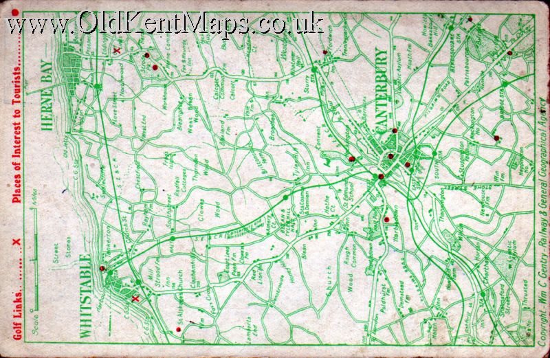
Wm.C.Gentry. Nº 4. Map of Canterbury,Whitstable & Herne Bay. overprinted in red with Golf Links & Places of Interest [pre 1923] |
|
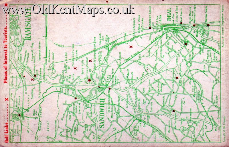
Wm.C.Gentry. Nº 3. Map of Isle of Thanet-Ramsgate,Sandwich & Deal. overprinted in red with Golf Links & Places of Interest [pre 1923] |

|
Wm.C.Gentry. Nº 2. Map of Isle of Thanet-Westgate,Margate,Broadstairs and Ramsgate. overprinted in black Isle of Thanet. Golf Links & Places of Interest [pre 1923] |
|
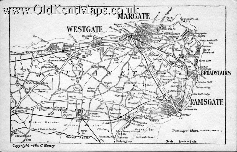
Wm.C.Gentry. Nº 1. Map of Isle of Thanet-Westgate,Margate,Broadstairs and Ramsgate. overprinted in black Isle of Thanet. Golf Links & Places of Interest [pre 1923] |
|
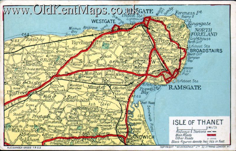
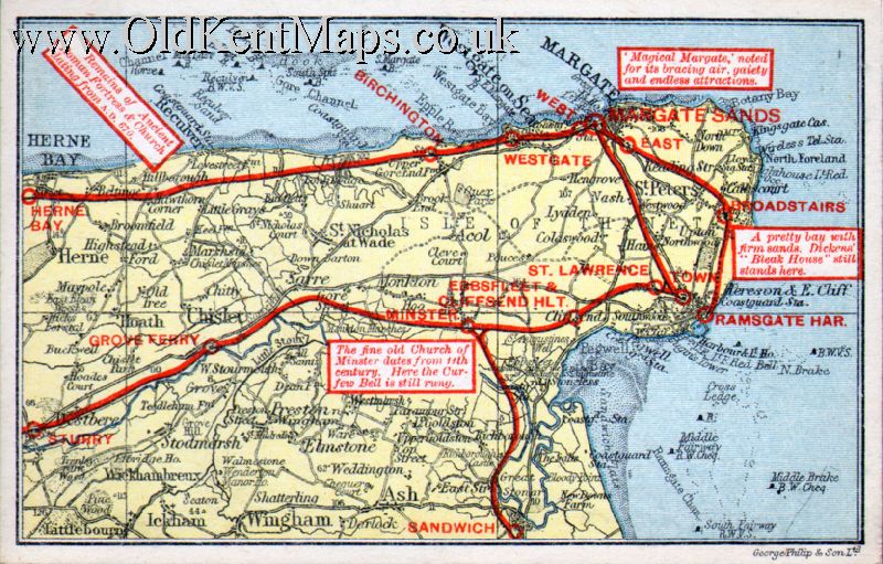
"Geographia" Ltd., Nº 1. Isle of Thanet. Reculvers to Sandwich. [pre 1918] |
|
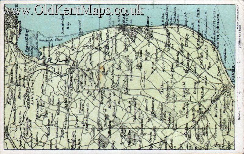
W.& A.K.Johnston Ltd Nº 1. East Coast of Kent Ramsgate to Dover. [pre 1920s] |
|
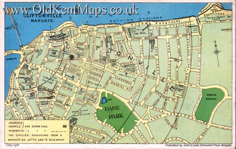
John C.Lane. Nº 1. Lane’s New Street Map of Cliftonville Margate.[1913] |
|
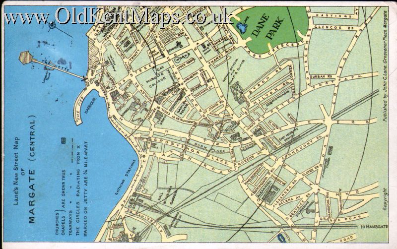
John C.Lane. Nº 2. Lane’s New Street Map of Margate (Central).[1913] |
|
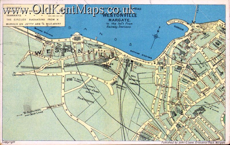
John C.Lane. Nº 3. Lane’s New Street Map of Westonville Margate (Central).[1912] |
|
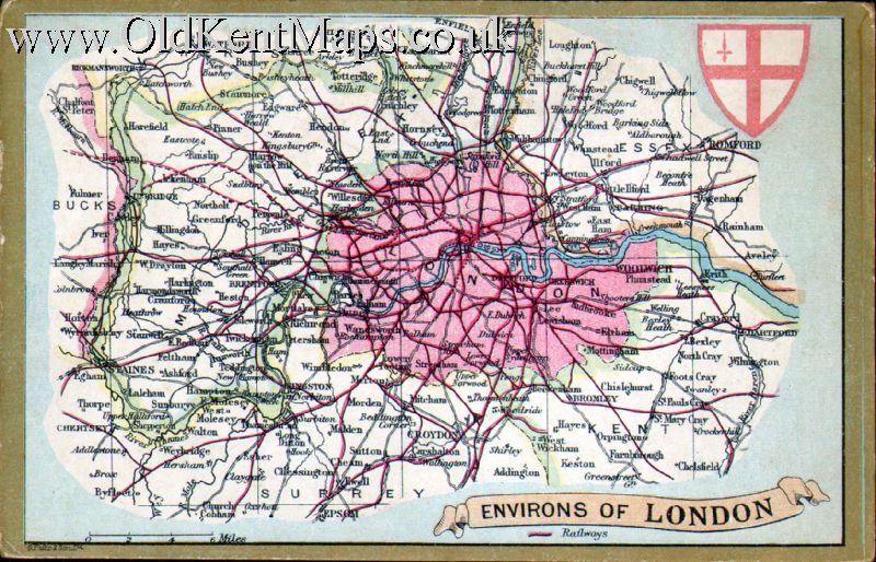
E.Wrench.Ltd/G.philip & Son Ltd. Nº 1. Environs of London [1902-06] |
|
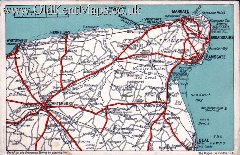
McCorquodale & Cº Limited. Nº 3. Isle of Thanet [Reculvers to Sandwich]. [pre1923] |
|
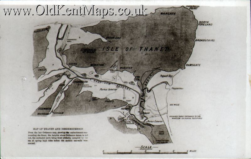
Unidentified Publisher Nº 3. Ordnance Survey Map of the Isle of Thanet [1920s]? |
 |
The Mappa Co. Nº 1. Map of The Isle of Thanet. [1930s]? |
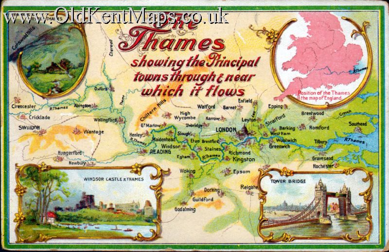 |
Unidentified Publisher Nº 4 The Thames from Source to Isle of Sheppey. [c1920s?] Reward Card PPc size. |
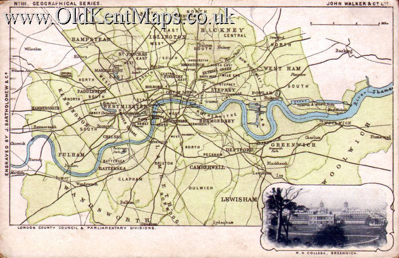
| Walker / Bartholomew No 111 c1900 J.Walker & Cº.Ltd. / [J.Bartholomew & Cº] Nº 1 [Walker Identifying number 111.] Environs of London.[London County Council & Parliamentary Divisions] Vignette of R.N. College Greenwich.[1940s] |
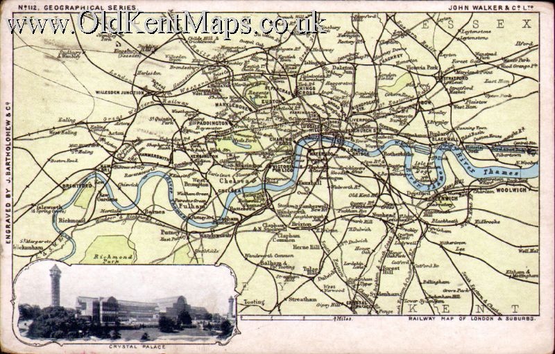
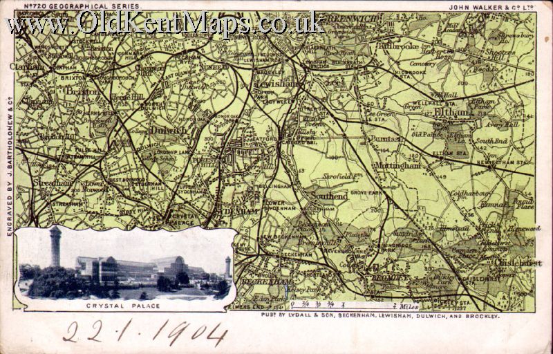
| Walker / Bartholomew No 112 c1900 J.Walker & Cº.Ltd. / [J.Bartholomew & Cº] Nº 2 [Walker Identifying number 112.] Environs of London.[Railway Map of London & Suburbs] [1940s] Vignette of Crystal Palace |
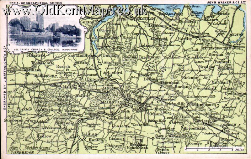
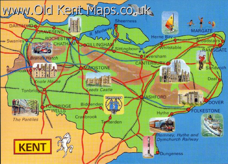
| Walker / Bartholomew No 214 c1900 J.Walker & Cº.Ltd. / [J.Bartholomew & Cº] Nº 3 [Walker Identifying number 214.] Mid Kent centred on Maidstone [pre 1918] Vignette of All Saints Ch & College Maidstone. |
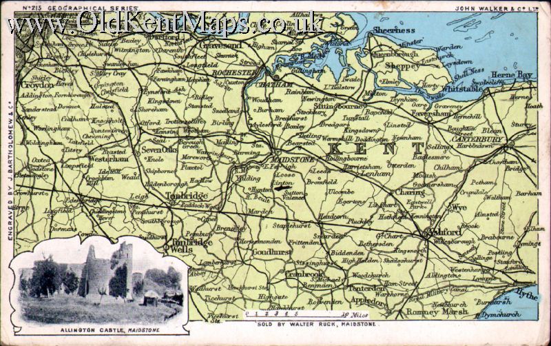
| Walker / Bartholomew No 215 c1900 J.Walker & Cº.Ltd. / [J.Bartholomew & Cº] Nº 4. [Walker Identifying number 215.] West & Mid Kent centred on Maidstone [pre 1918] Vignette of Allington Castle Maidstone. |
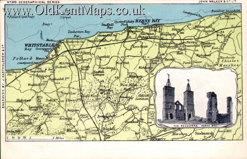
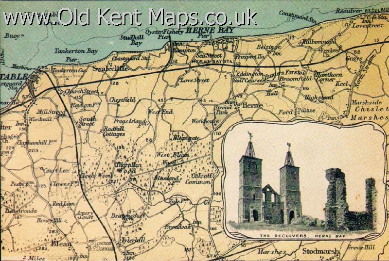
| Walker / Bartholomew No 220 c1900 J.Walker & Cº.Ltd. / [J.Bartholomew & Cº] Nº 5. [Walker Identifying number 220.] Whitstable / Herne Bay [pre 1918] Vignette of The Reculvers, Herne Bay |
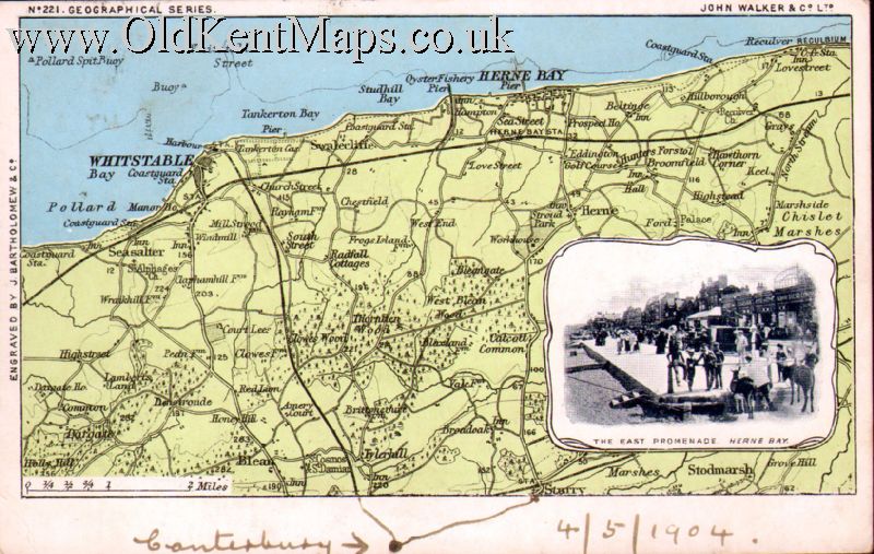
| Walker / Bartholomew No 221 c1900 J.Walker & Cº.Ltd. / [J.Bartholomew & Cº] Nº 6. [Walker Identifying number 221.] Whitstable / Herne Bay [1904] Vignette of The East Promenade, Herne Bay |
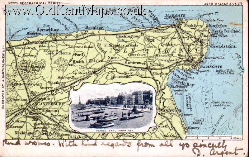
| Walker / Bartholomew No 223 c1900 J.Walker & Cº.Ltd. / [J.Bartholomew & Cº] Nº 7. [Walker Identifying number 223.] Isle of Thanet [1903] Vignette of Herne Bay, From Pier. |
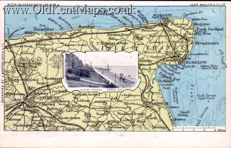
| Walker / Bartholomew No 224 c1900 J.Walker & Cº.Ltd. / [J.Bartholomew & Cº] Nº 8. [Walker Identifying number 224.] Isle of Thanet [c1903] Vignette of Marine Parade,Herne Bay. |
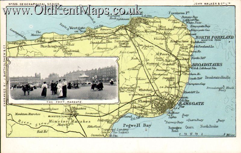
| Walker / Bartholomew No 225 c1900 J.Walker & Cº.Ltd. / [J.Bartholomew & Cº] Nº 9. [Walker Identifying number 225.] Isle of Thanet [1907] Vignette of The Fort,Margate. |
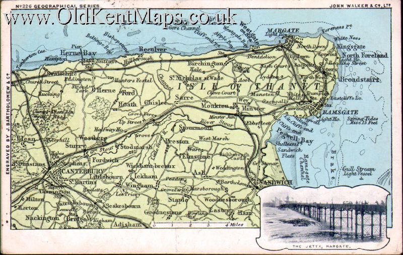
| Walker / Bartholomew No 226 c1900 J.Walker & Cº.Ltd. / [J.Bartholomew & Cº]Nº 10. [Walker Identifying number 226.] Isle of Thanet [1903] Vignette of The Jetty,Margate. |
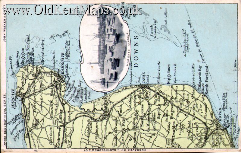
| Walker / Bartholomew No 227 c1900 J.Walker & Cº.Ltd. / [J.Bartholomew & Cº] Nº 11. [Walker Identifying number 227.] Isle of Thanet & Coast to Dover [1903] Vignette of Margate Harbour. |
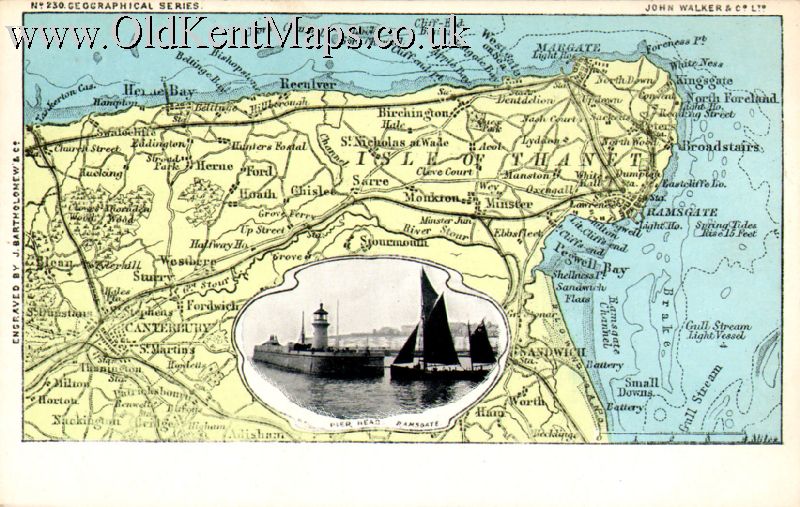
| Walker / Bartholomew No 230 c1900 J.Walker & Cº.Ltd. / [J.Bartholomew & Cº] Nº 12.[Walker Identifying number 230.] Isle of Thanet [1903] Vignette of Pier Head Ramsgate. |
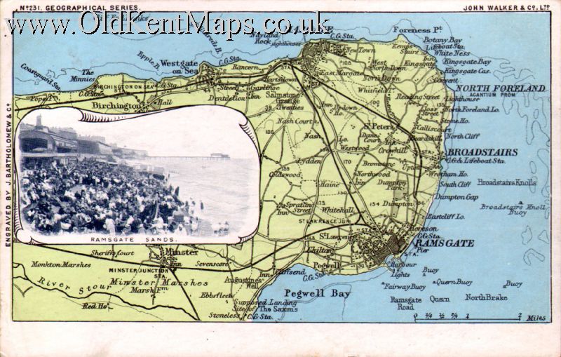
| Walker / Bartholomew No 231 c1900 J.Walker & Cº.Ltd. / [J.Bartholomew & Cº] Nº 13.[Walker Identifying number 231.] Isle of Thanet [1906] Vignette of Ramsgate Sands. |
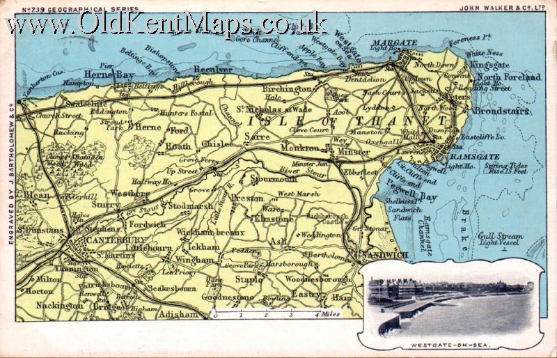
| Walker / Bartholomew No 239 c1900 Actually Nº 739!! I think J.Walker & Cº.Ltd. /[J.Bartholomew & Cº] Nº 24.[Walker Identifying number 739.] Isle of Thanet [1903] Vignette of Westgate-on-Sea. |
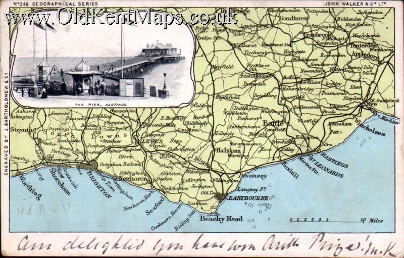
| Walker / Bartholomew No 246 c1900 J.Walker & Cº.Ltd. / [J.Bartholomew & Cº] Nº 14.[Walker Identifying number 246.] South Coast [Worthing to Rye] [1903] Vignette of The Pier,Hastings. |
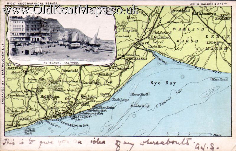
| Walker / Bartholomew No 247 c1900 J.Walker & Cº.Ltd. / [J.Bartholomew & Cº] Nº 15. [Walker Identifying number 247.] South Coast [Bexhill to Romney Marsh] [1903] Vignette of The Beach,Hastings. |
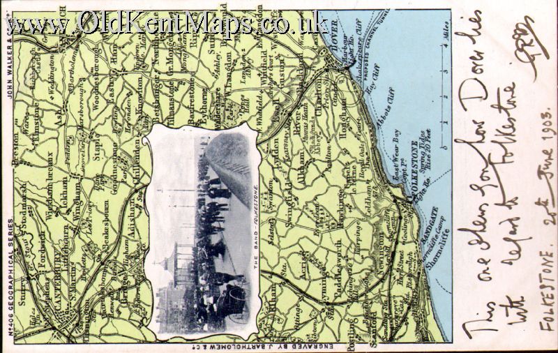
| Walker / Bartholomew No 406 c1900 J.Walker & Cº.Ltd. / [J.Bartholomew & Cº] Nº 16. [Walker Identifying number 406.] South Coast [Hythe to Dover] [1903] Vignette of The Band,Folkestone. |
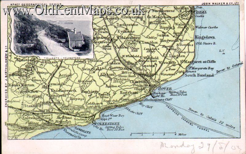
| Walker / Bartholomew No 407 c1900 J.Walker & Cº.Ltd. / [J.Bartholomew & Cº] Nº 17. [Walker Identifying number 407.] South Coast [Hythe to Dover] [1904] Vignette of Tolgate,Folkestone. |
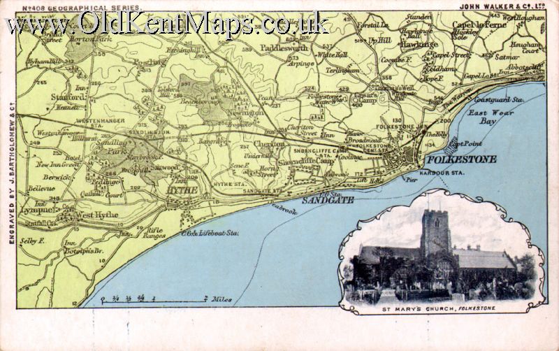
| Walker / Bartholomew No 408 c1900 J.Walker & Cº.Ltd. / [J.Bartholomew & Cº] Nº 18. [Walker Identifying number 408.] South Coast [Hythe/Sandgate to Folkestone] [1904] Vignette of St.Marys Church,Folkestone. |
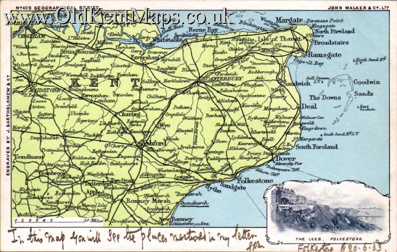
| Walker / Bartholomew No 409 c1900 J.Walker & Cº.Ltd. / [J.Bartholomew & Cº] Nº 19. [Walker Identifying number 409.] Kent [1903] Vignette of The Lees,Folkestone. |
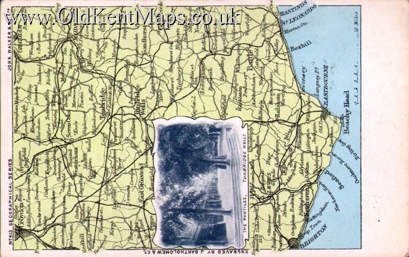
| Walker / Bartholomew No 415 c1900 J.Walker & Cº.Ltd. / [J.Bartholomew & Cº] Nº 20. [Walker Identifying number 415.] Croydon/Chatham,South to Beachy Head [c1904] Vignette of The Pantiles,Tunbridge Wells. |
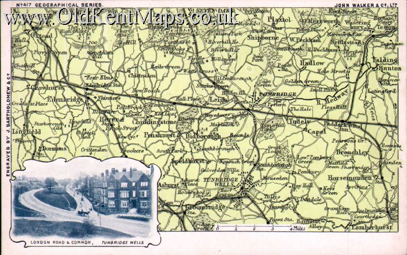
| Walker / Bartholomew No 417 c1900 J.Walker & Cº.Ltd. / [J.Bartholomew & Cº] Nº 21. [Walker Identifying number 417.] Westerham/Teston,South to Groombridge & Lamberhurst [c1904] Vignette of London Road & Common,Tunbridge Wells. |
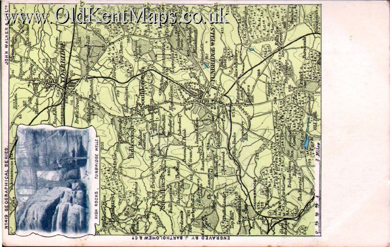
| Walker / Bartholomew No 419 c1900 J.Walker & Cº.Ltd. /[J.Bartholomew & Cº] Nº 22.[Walker Identifying number 419. Tonbridge South to Groombridge & Tunbridge Wells. [c1904] Vignette of High Rocks,Tunbridge Wells. |
| Walker / Bartholomew No 720 c1900 J.Walker & Cº.Ltd. /[J.Bartholomew & Cº] Nº 23.[Walker Identifying number 720. South East London down to Clapham/Chislehurst [c1904] Vignette of Crystal Palace. |
| Dunlop Rubber Co.,Ltd. |

| Co Elgate Postcards. Ramsgate. Stylised road map following ’The Pilgrims Way’ from Winchester/Canterbury |
| L&G / The 'Premier' Series.2. Photographic picture style map Kent/Sussex with image, Beachy Head/Romney [pre 1918] |
| Reculver Cards.Herne Bay Later reproduction of a 1904- Bartholomews map on postcard Nº 220 RECULVERS. |
| The National Postal Museum.1. Rye and Romney Marsh reproduction of John Cary’s map of E&W 1816. 1991 |
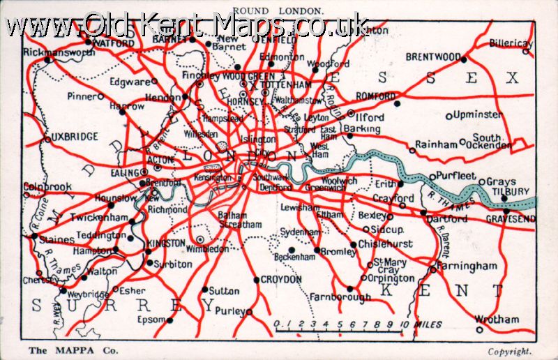
| The Mappa Co. London,E.C.4 London Environs map detailing the major roads out of the city |
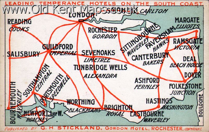
| G.H.Stickland,Gordon Hotel,Rochester Outline map covering Reading / Dover naming towns with Temperance Hotels. |
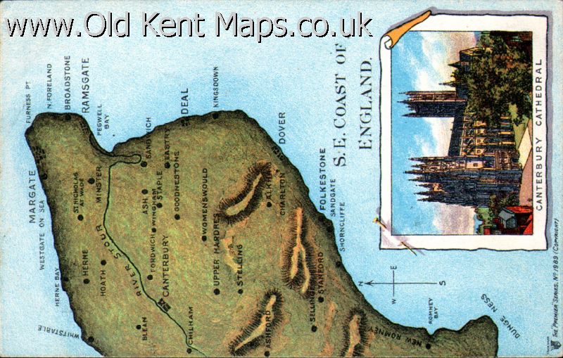
| L&G / The 'Premier' Series.1. Stylised pt East Kent map with image of Canterbury Cathedral [ pre 1918] |
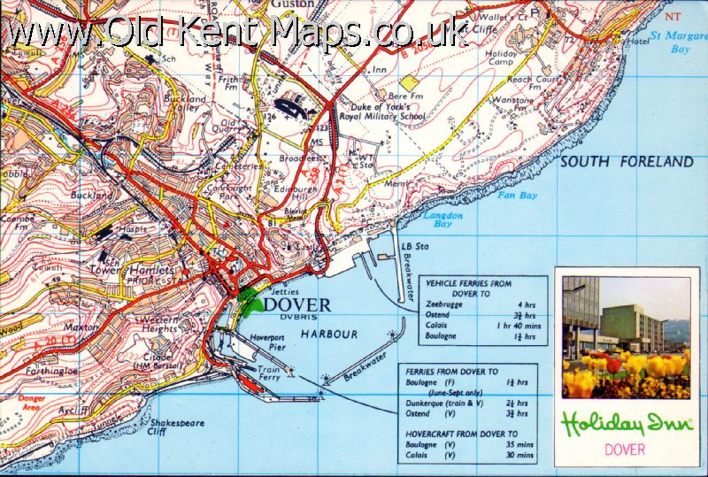
| Holiday Inn / O.S. Photograph of the Holiday Inn Dover on a O.S. source map |
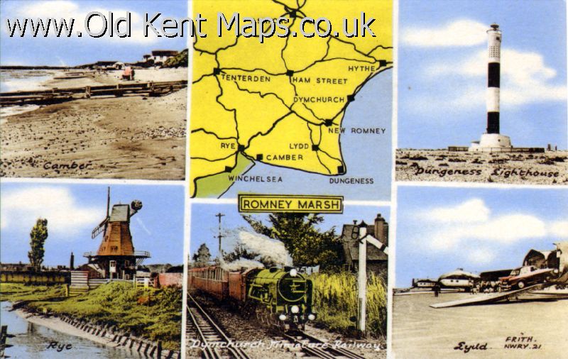
| F.Frith & Co.,Ltd.,Reigate. Romney area map,photographic surround Lydd Airport, Rye Watermill &c. |
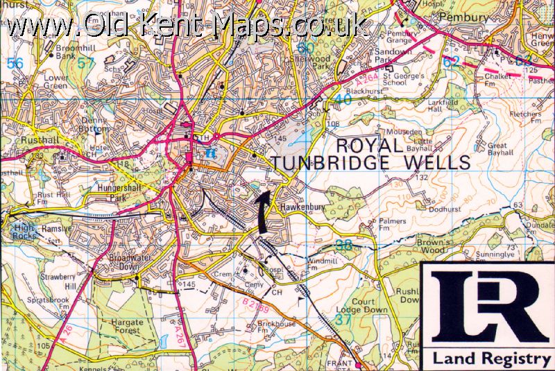
| Ordnance Survey./ Land Registry.1. Tunbridge Wells Town Plan [c1990] |
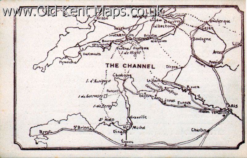
| Little Bazaar. [Petit Bazaar] Outline map of Southern England/Northern France with roads & Ferry routes |
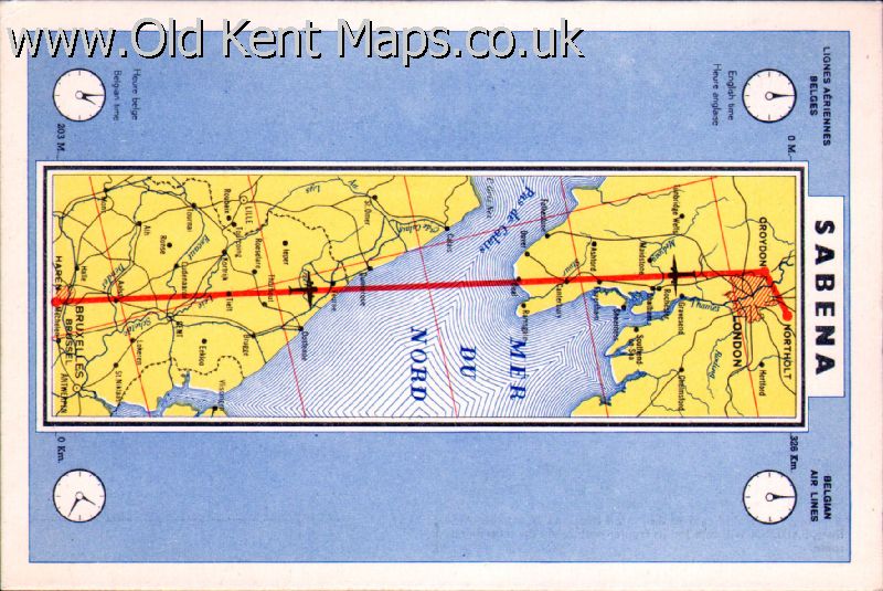
| Sabena Airline.1. Strip map of Kent, North France & Belgium, ‘flightpath’ London/Brussels. |
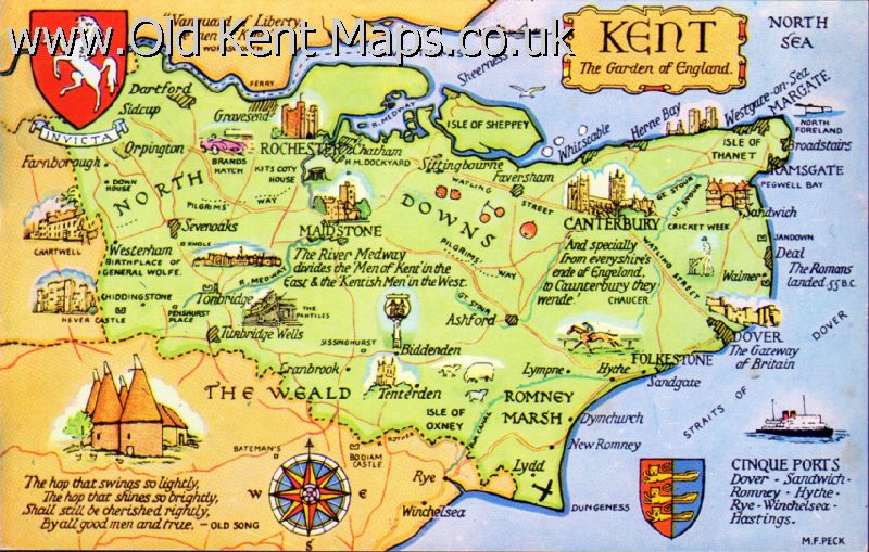
| Valentine & Sons.Ltd.Dundee & London. Stylised map of Kent-with vignettes of places of interest |
| Valentine & Sons.Ltd.Dundee & London. Stylised map of North Kent with Isle of Sheppey |
| E.T.W.Dennis & Sons Ltd., Scarborough. Pale Kent-with ‘South East England’ and a ‘sunburst’ |
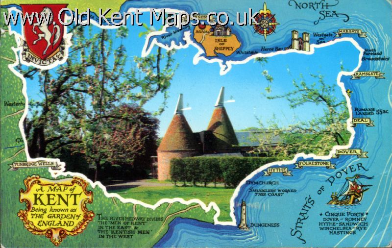
| Photo Precision Limited St.Ives,Huntingdon Kent border around Photograph of Hop Houses |
| Unidentified Publisher A photographic map of the S.E Coast [Essex/Hampshire/ 4 Photographs] |
| Judges of Hastings. Kent with ‘Invicta’ Horse, photographic vignettes |
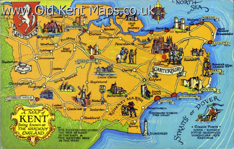
| J.Salmon Ltd.,Sevenoaks.1. Stylised Map of Kent as Nº 20 above but lacking a border with colour variation |
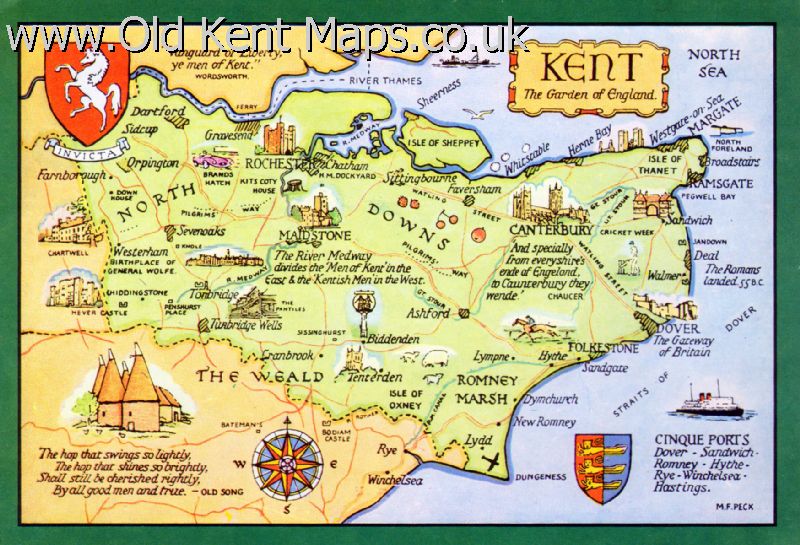
| J.Salmon Ltd.,Sevenoaks.2. Stylised Map with heavy green border,Kent & Cinque Ports Shields,Compass Rose |
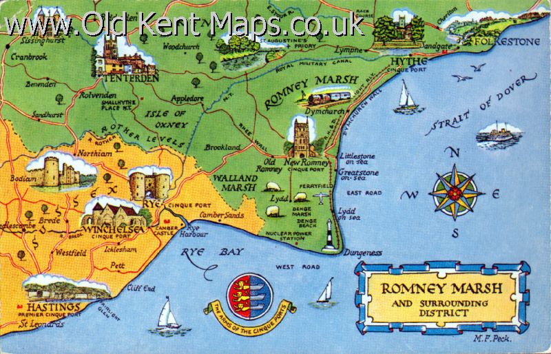
| J.Salmon Ltd.,Sevenoaks. 3. Stylised map of Romney Marsh/East Sussex. Cinque Ports Shield,Compass Rose |
| Unidentified Publisher Kent- Invicta Shield,title in roccoco type surround |
 |
Shoesmith & Etheridge Ltd.Hastings.1. Uncoloured. Stylised East Kent with circle around Canterbury out to coast similar to above |
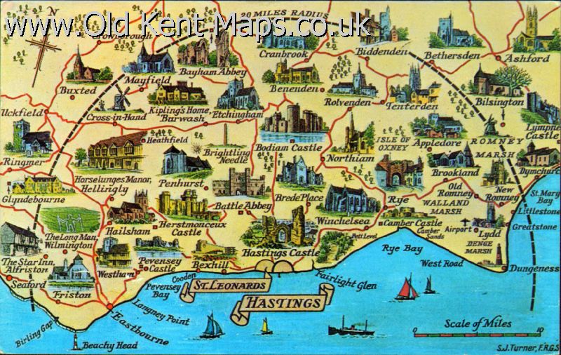 |
[Shoesmith & Etheridge Ltd.Hastings.2] Sussex/Kent with 20 mile Circle around Hastings out to coast |

| Shoesmith & Etheridge Ltd.Hastings.3. Stylised Yellow and blue East Kent with circle around Canterbury out to coast similar to below |

| The Photographic Greeting Card Co. Ltd. Stylised Road map of East Kent with photographic surround [12]. |
| Geographia / AA OS based reproduction SW Kent multicolour Croydon/Redhill/Sevenoaks |
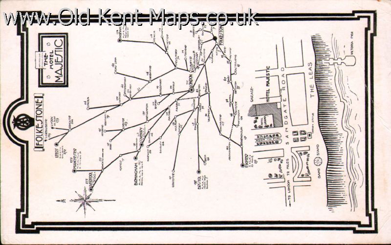
| The Hotel Majestic.Folkestone. / AA. Folkestone Hotel Road map and town plan |

| Daily Mail /.... Herne Bay?. E&W = Herne Bay water purity |
| Postcards Revision List |
| Printed Maps of Kent | Tony Burgess 2011 |